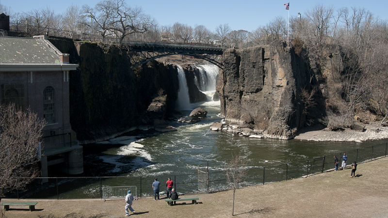
The Great Falls on the Passaic River in Paterson, NJ were part of the river basin resiliency study. Ed Murray
NORTHERN NEW JERSEY, 20,000 B.C.—The massive Wisconsin Glacier has advanced into the state’s northern reaches, plowing forth mountains of soil, rocks and ice. A river flowing through the area is suddenly blocked. Its waters begin pooling between the glacier and nearby ridges, forming what geologists now call Glacial Lake Passaic.
As the Ice Age subsides, the glacier retreats, further carving up the land and flooding it with its melting waters. When the lake is finally drained a few millennia later, the Passaic River would flow over an altered landscape and take on a winding new route, zig-zagging north and south for 90 miles. Today, the ancient lake seems to briefly resurrect during heavy rains, as flooding strikes fast and deep along the river’s banks.
“Passaic County has a long history of grappling with flooding,” said Elizabeth Ward, a principal planner for the county that adopted the river’s name. “The county and its municipalities have been trying to mitigate flood events for a long time.”
But unlike the Ice Age, the river now flows through an area that 2.5 million people call home. It starts in a mountainous rural area and flows down to the Great Swamp National Wildlife Refuge, an ancient vestige of Lake Passaic; swings north through populous suburbs; crashes down through the Great Falls at Paterson; pivots 180 degrees and heads south through downtown Newark and its port district; and finally empties into tidal Newark Bay.
The route is emblematic of the multidimensional challenge North Jersey faces as it confronts climate change. From the Jersey Shore to the “Gold Coast” along the Hudson River to the mountainous Skylands to the west, the Garden State’s rails and roads run through every conceivable setting. Now the local governments which know them best are leading planning efforts to ensure their transportation systems are both ready for climate change and not contributing it.
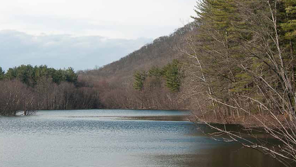
The Wanaque Reservoir in the Passaic River Basin.
Passaic River Basin Study
Under the auspices of the North Jersey Transportation Planning Authority, eight New Jersey counties within the Passaic’s 935-square-mile watershed worked together to create the Passaic River Basin Climate Resilience Planning Study, completed in 2019. The study focused on potential impacts that climate change will have on the area’s transportation network and produced a list of 71 adaptation strategies that could make its infrastructure more resilient to existing and future heat or flooding events.
Those strategies were boiled down to seven categories: reducing thermal expansion, use of heat-resistant materials, preventing system failure, improving stormwater drainage, increasing flood protection, reducing flood damage, and the implementation of regionwide policies for matters such as land use development and transportation technologies.
Virginia Michelin, principal environmental planner in Morris County, where the Passaic River begins, said the planning process highlighted the need for greater consistency across counties in their approach to climate change.
“Right now, one county does one thing, another does its own thing,” Michelin said. “They need to work well together. The state needs to put forth better standards to take climate change into account, whether they be larger culverts or heat-resistant pavements."
Of 3,245 transportation assets evaluated, 10 percent were found to be “highly vulnerable” to existing and future heat and/or floods events. The document identifies these assets and prescribes which of the strategies can be applied to improve them. Morris County Transportation Planner John Hayes noted that “It’s all situational,” and each road and bridge will require its own solutions depending on the ground conditions.
The plan’s implementation will not happen overnight. It will require funding, time and perhaps most importantly, buy-in from both policymakers and residents.
Ward believes she’s seeing plenty of it in Passaic County. While major rain events like Hurricane Irene in 2011 have placed climate change firmly on residents’ radar, the inundations caused by ordinary storms are in a sense a more telling indicator of the problem.
“Down in the urban area, there’s been lots of nuisance flooding occurring more rapidly and the infrastructure is aging,” Ward said. “I’d say on the whole, people are aware and open to different solutions.”
 Red Lines at the Shore
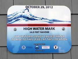
The signs of climate change are literally everywhere in coastal Monmouth County. Through its High Water Mark Initiative, the county has installed signs on buildings, roadsides and prominent pedestrian areas showing the heights flood waters reached during Hurricanes Sandy and Irene.
The heights are depicted by a thick red line with a note disclosing how many feet the point is above NAVD88 (roughly mean sea level). Part of what’s made the signs such effective public education tools is that the sight of them can be jarring.
“It’s supposed to make you stop and think, even though it’s a beautiful day and you’re enjoying yourself, there might be a day— there was in the past—where that’s where the water is,” Monmouth County Assistant Planning Director Joe Barris said. “You’ve always got to remember, it happened once, it can happen again. You have to be alert, be prepared."
They’ve even become something of a tourist attraction. Barris said his favorite is a roadside sign a few blocks from the Manasquan Inlet, a hot spot for beach tourism and surfing.
“So many people walk by it on their way back and forth to the beach and you actually see people taking pictures with it. They’re taking selfies with their friends in front of the High Water Mark sign,” he said.
Participation in the initiative has been voluntary for municipalities. As of July 2019, 16 towns had opted in and a few others were preparing to. Given the sensitivity of the subject, the county let the towns choose where the signs were placed; most are in public spots, away from residential neighborhoods.
Membership has its perks. High Water Mark municipalities earn points through the Federal Emergency Management Administration’s Community Rating System (CRS), which helps lower flood insurance policy premiums for homeowners. Towns can also earn CRS points for a variety of steps that improve their resilience, such as raising roadways, drainage system upgrades, mapping hazards or drafting emergency response plans. The county is now saving residents $2.4 million annually through its accumulation of CRS points, and Barris said other counties have begun replicating their work.
Monmouth County was one of the hardest hit by Sandy in 2012, with one in 20 of its homes suffering severe flood damage. The devastation came only a year after Hurricane Irene demolished boardwalks and inundated the county’s waterways with 6-8 inches of rain. Barris said the one-two punch of hurricanes in a state that hadn’t been hit by one in decades opened residents’ eyes to the signs that their environment is changing.
“You are now seeing nuisance flooding in high tide, during full moons, during winds out of the east, and it’s slowly creeping and getting worse over time,” he said. “The thing isn’t so much, are we preparing for the big one? It’s how are we preparing for the long term.
A City Drafts its Own Climate Plan
One small city is attacking climate change at its roots. Just across the Hudson River from Manhattan, the waterfront commuter enclave of Hoboken enacted its own municipal-level plan to achieve carbon neutrality by 2050. During Hurricane Sandy, half the city was flooded, leaving an estimated 20,000 people stranded, surrounded by water. The New Jersey National Guard was called in to help with rescues.
Signing the document into effect on Earth Day of 2019, Mayor Ravi Bhalla said, “Now, more than ever, it is up to local governments to take the lead in combatting climate change. Our Climate Action Plan demonstrates that we are ready, willing and able to reduce emissions, minimize our carbon footprint, and take forward thinking steps to sustain coastal communities like Hoboken for future generations.”
Transportation is a major part of the strategy. The plan calls for installing more electric vehicle chargers across the city, replacing street and traffic lights with energy-efficient lighting, phasing in hybrid and electric vehicles for its municipal fleet, adding bike lanes, and offering free bus services.
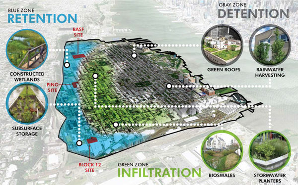
Green infrastructure strategy for the city of Hoboken.
Hoboken is pairing its mitigation efforts with some of the most innovative adaptation approaches in the state. In October, the city broke ground on the Northwest Resiliency Park, a 5-acre tract with underground tanks capable of storing 1 million gallons of stormwater. The project tailored to solve a drainage problem that will worsen in the city as climate change brings more intense storms, according to Thomas Herrington, coastal community resilience specialist for the New Jersey Sea Grant Consortium and associate director of the Monmouth University Urban Coast Institute.
Hoboken’s stormwater drainage pipes empty at its waterfront bulkheads into the Hudson. During very high tides or storm surges, the pipes become submerged, making outfall impossible and causing streets and properties to flood during heavy rains. Projects like the Resiliency Park enable the city to pump stormwater into a temporary hold, then release it when the coast is clear, Herrington said. The city is also implementing green and grey infrastructure improvements along the waterfront to keep the river water out.
“That is really the challenge for these areas that date back to the late 19th, early 20th century,” Herrington said. “They are structurally very hard to adapt, unless you start tearing them down. So the solution is to prevent them from flooding.”
Coastal Concern
Studies show New Jersey will be twice as vulnerable to rising seas as other areas. In addition to polar ice melt raising sea levels, the Mid-Atlantic is sinking, thanks to the same glacial retreat that once impacted the Passaic River Basin. During the Ice Age, the colossal weight of the ice sheets piled across the northern portion of the continent caused the Mid-Atlantic coast to bulge upward, like the smaller kid on one end of a see-saw. Today, even though the ice has been gone for thousands of years, the coast continues to sink back into place.
Herrington said communities along New Jersey’s coastal barrier islands and tidal back bays are at the front lines. They are already finding that flooding that used to occur five times per year in the 1950s is now happening 20 times, and it’s unpredictable, he said.
“When I talk to people in the communities, they say, ‘I know if a nor’easter comes, it’s going to flood the town and I know what to do to prepare for it. But I don’t know what is going to happen tomorrow anymore. I sometimes look out the window on a perfectly nice day, the road is flooded and I don’t know why,’” he said. ♦
Karl Vilacoba is the Communications Director for the Monmouth University Urban Coast Institute.